

A planner’s checklist: What telematics data can (and can’t) do for freight planning
Telematics data for freight planning complements traditional sources. Our checklists share what telematics data can and can’t do to support freight planning.


Truck parking has reached a new priority level in state freight planning, and DOTs are turning to data-informed stop analytics insights to address it. DOT planners are using new data to unlock truck parking details, including detailed stop behavior across regions, neighborhoods and road segments. Stop analytics data also informs wider planning initiatives including smarter infrastructure, safety improvements, curbside management and EV plans.
Here are some examples of how DOTs are using stop analytics data for truck parking planning.
Stop analytics data is widely available for all vehicles, but private vehicle data can muddy or dilute commercial vehicle analytics. By understanding where and how stops happen for commercial vehicles only, DOTs can prioritize investments more effectively than by using data for a wider transportation segment.
Commercial-specific stop behavior insights strengthen multiple infrastructure planning and transportation strategies for DOTs.
DOTs can use stop analytics to identify truck stopping times, locations and duration to plan rest areas, pinpoint unauthorized parking and support NHFP/INFRA applications. Stop analytics also provide a methodology for ongoing monitoring of truck parking adequacy as required for state freight plans.
Truck parking planning included in state freight plans connect directly to federal compliance requirements. Failing to report correctly creates compliance risk and can stall critical project approvals. Real-world commercial vehicle data provides accurate class-specific traffic counts for Highway Performance Monitoring System (HPMS) and Model Inventory of Roadway Elements (MIRE) compliance.
Stop analytics help DOTs identify or confirm appropriate areas for commercial EV vehicle support. Data can locate zones where vehicles remain parked long enough to justify public charging infrastructure. Based on vehicle volume and stop times, DOTs can estimate how many charging stations may be needed for each location.
In high traffic and dense urban areas, DOT planners can use data to segment short stops by location and time of day. Segmenting data by parameters like frequency and peak times informs safety audits, street design and curb management.
DOTs can collect information outside their jurisdiction to help identify potential partnerships. For example, stop analytics can be used to track cross-jurisdictional stop trends and truck parking behavior across counties, MPOs or other regions. This data can be used to coordinate long-range freight strategies between localities.
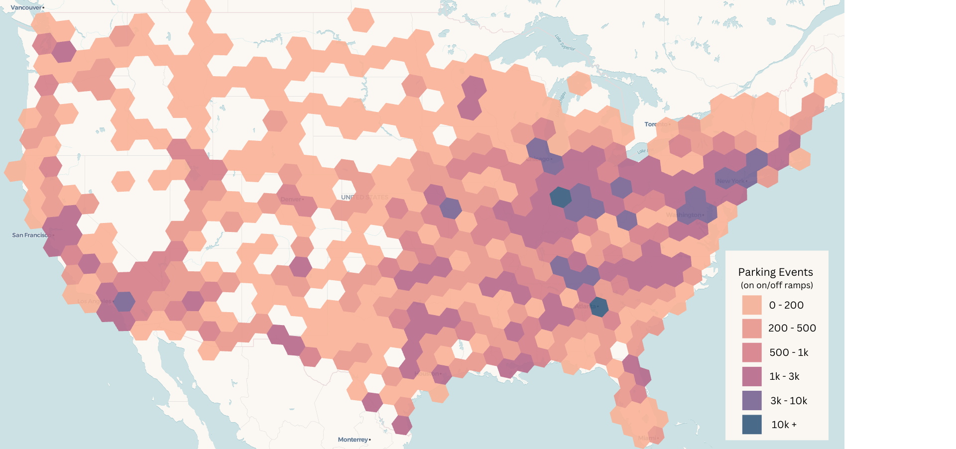
Stop data provides the empirical foundation needed to justify infrastructure investments through programs like INFRA grants and IIJA implementation. A widespread analysis can show that ramp parking is not isolated to a few problematic locations but represents a systematic capacity shortfall affecting interstate commerce.
Rather than expanding parking capacity by uniform geographic distribution, stop data enables agencies to identify specific corridors where resources are most needed. Observed demand patterns allow planners to target long-haul corridors (trips exceeding 500 miles) that have demonstrated overnight capacity gaps.
DOT agencies can evaluate ramp parking frequency against infrastructure deterioration costs and crash risk to calculate the return on investment for parking capacity additions. Vehicle collisions involving heavy-duty trucks cost an average of $163,000 per collision, indicating the financial implications associated with avoiding these collisions is massive. In addition, trucks parked on ramps accelerate pavement deterioration and create collision hazards.
Altitude’s Stop Analytics API offers intuitive filters and geographic views so that DOT planners can explore commercial vehicle stop behavior in context.
In our analysis of over 330,000 long-duration parking events, we used real-world movement data to uncover some important takeaways about truck ramp parking. This is the kind of data that DOTs can use to understand what’s driving truck parking, to identify high-risk hot spots and to build defensible, data-backed recommendations.
For example, our analysis found strong correlation between ramp parking and hours-of-service (HOS) regulations. The analysis reveals how HOS requirements bump against infrastructure capacity to create parking problems. The median truck drives for 9.7 hours before a ramp parking event, demonstrating that drivers are running up against their 11-hour driving limits with no available authorized parking.
Our national study argues for nationwide corridor prioritization. The parking data reveals that this isn’t a state-specific issue. DOTs will have to prioritize long-haul corridors over state allocation formulas.
Data-backed insights support a quantified approach to the problem. Being able to point to two million ramp parking events annually provides a baseline for measuring current funding levels. Quantifiable data can help determine if resources adequately address the magnitude of the challenge, and if not, what’s needed.
Reliable stop analytics data helps transportation agencies address long-standing gaps in understanding stop and parking behavior. Built on first-party commercial vehicle movements, Altitude supports DOTs and their partners in making confident, data-driven decisions.
Download our Nationwide Study of Truck Parking on Interstate Ramps and learn how the data can help support your parking planning.
DOTs can use stop analytics data to identify where and how long trucks are parking, including on unauthorized locations like interstate ramps. This data reveals stopping patterns, duration and location trends that help planners prioritize rest area investments, monitor truck parking adequacy for state freight plans, and support funding applications like NHFP and INFRA grants.
Ramp parking is closely tied to hours-of-service regulations, which require truck drivers to stop once they hit their 11-hour driving limit. Data shows the median truck drives 9.7 hours before a ramp parking event, indicating drivers are running out of legal parking options as they approach that limit, resulting in over two million ramp parking events annually.
Stop analytics provide the empirical evidence DOTs need to support applications for programs like INFRA grants and IIJA implementation funding. By quantifying ramp parking events across corridors, DOTs can demonstrate that parking shortages represent a systemic capacity gap affecting interstate commerce rather than isolated local problems, strengthening the case for federal investment.
Yes. Stop analytics data helps DOTs identify locations where commercial vehicles remain parked long enough to justify public heavy-duty vehicle charging infrastructure. Based on vehicle volume and stop duration at each location, DOTs can estimate how many EV charging stations are needed to support demand.
Telematics data for freight planning complements traditional sources. Our checklists share what telematics data can and can’t do to support freight planning.
New data sources for MPO freight planning: 3 overlooked metrics that reveal regional trends before they hit your dashboard.
State DOTs can forecast truck traffic earlier by watching freight metrics from city and port data. Here are 3 signals worth tracking.