
Freight route planning for events: Soccer cities with the best traffic stats
See how freight route planning for weekday events can cut harsh braking risk. Real traffic data from Leo Messi and Cristiano Ronaldo’s June games reveals why.


Las Vegas, NV (October 16, 2024) – Altitude by Geotab, A two-week closure in June of the highly-traveled Memphis-Arkansas bridge connecting the states of Arkansas and Tennessee resulted in an 1750% increase in harsh driving events such as harsh braking and fast accelerations. An Altitude by Geotab study on commercial freight data on 5 key U.S. bridges reveals that closures, whether short or long term, can have a significant impact on traffic congestion, increased risk of harsh events, and disruptions to the movement of goods beyond the region.
Geotab ITS provided a snapshot into what can be expected with a longer term replacement project and 2026 planned closure of the Memphis-Arkansas Bridge.
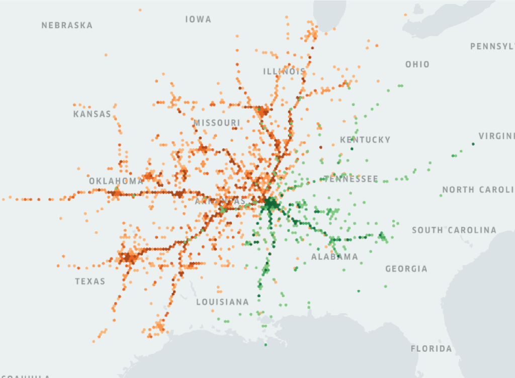
A map showing origin and destination insights for long-haul commercial vehicles. Green hexagonal areas indicate the journey stop locations of vehicles that crossed the bridge heading from Tennessee into Arkansas while en route to their destinations. Orange hexagonal areas indicate the journey stop locations of vehicles that crossed the bridge from Arkansas to Tennessee.
“Bridges are critical to communities whether they connect cities, states or large regional hubs and definitely need to be cared for, maintained and replaced. Using our commercial vehicle freight data, we conducted analyses of five important bridges across North America to demonstrate the potential effects of a significant disruption on the surrounding roads, driver safety, and regional economies,” said Geotab’s Nate Veeh, Associate Vice-President, Altitude by Geotab. “These bridges had a lot to tell us including how far-reaching the impacts of a potential bridge shutdown could be on more distant locations’ supply chains.”
In its bridge analysis report, Altitude by Geotab studied the widespread effects of potential closures to show organizations how they can form better transportation plans with real world data. The study focused on five major U.S. bridges in and across California, New York, Tennessee, Michigan and Maryland and included the impact of closures, severe weather, and traffic patterns so that communities can prepare for replacement projects in advance.
The Vincent Thomas Bridge – California
George Washington Bridge – Between New Jersey and New York
Ambassador Bridge – Between Detroit, Michigan and Windsor, Ontario
Francis Scott Key Bridge – Baltimore, Maryland
“Our data and data insights from our bridge analyses helped us assess the key aspects of a transportation network’s integrity: infrastructure resiliency, roadway safety and transportation efficiency. Each of the bridges we studied provided us with unique viewpoints ranging from how extra traffic could impact alternate routes reasonably handle, how motorist safety is impacted through changing driver behaviors such as harsh acceleration and harsh braking and, the impact of movement of goods and services en route to their destinations and how far out closures could extend to. All of this data insight can be very helpful in anticipating and planning for bridge construction and making better transportation decisions that focus on safety, resilience and efficiency, “ concluded Nate.
At Altitude by Geotab, we help governments develop smarter resiliency plans.
Altitude by Geotab’s strong reputation and vast data resources uniquely position us to analyze the impact of these bridges. With 80 billion daily data points from over four million vehicles, we are a leader in transportation insights. Data-driven bridge resiliency plans help minimize disruptions to daily commutes.
Our data insights provide valuable context, such as vehicle classes and vocations, enabling cities and states to create plans that support last-mile and long-haul deliveries and prevent bridge disruptions from impacting supply chains. Efficient transit drives economic prosperity, and understanding the commercial ramifications of potential bridge disruptions helps regions enhance their preparedness.
Altitude by Geotab is a leading provider of advanced mobility insights and solutions for public and commercial sectors across North America. Headquartered in Oakville, Ontario, the company leverages its expertise in data analytics to help decision-makers gain a comprehensive understanding of road network movements. By delivering reliable and contextualized insights, it enables improved planning capabilities and better financial outcomes, while ensuring complete data confidentiality and privacy. Our solutions drive safer, more efficient, and sustainable mobility throughout North America. Learn more at altitude.geotab.com and follow us on LinkedIn.
Nicole Riddle
Senior Specialist, Strategic Communications
pr@geotab.com
See how freight route planning for weekday events can cut harsh braking risk. Real traffic data from Leo Messi and Cristiano Ronaldo’s June games reveals why.
Toll changes at the US-Canada border shifted truck traffic — and revealed the hidden freight congestion impact on delivery times, penalties and regional economic health.
Our Arizona case study illustrates how to capture true last-mile delivery behavior to inform infrastructure wear and tear, safety, curbside management, and more.