The three regional metrics for freight corridor analysis
Learn how freight corridor analysis helps planners identify stressed routes, forecast deterioration, plan detours and build defensible strategies to win funding.

Behind every data point in a state freight plan is a commitment to human safety. With several thousand people injured or killed over the past five years in collisions involving trucks parked on ramps, solving this parking crisis is a moral and operational imperative.
This has been a nationally recognized problem for over a decade (Jason’s Law was established in 2012) that is now poised to receive up to $200 million in funding. Now is the time to delve deeper into analysis to guide planning and development.
Altitude by Geotab in partnership with HNTB analyzed over 120,000 long-duration truck ramp parking events, extrapolated to over 300,000 annual long-duration events nationwide. The emerging temporal patterns provide an empirical foundation that planners have lacked. This data allows agencies to move past anecdotal evidence and use verified analytics to identify where truck parking demand is highest. This data can help justify federal funding for capacity expansion through Infrastructure Investment and Jobs Act (IIJA) grant applications.
In general, the eastern United States experiences a higher number of ramp parking events than the western United States. A frequency analysis shows that ramp parking events are most common around Atlanta and Indianapolis, indicated on the map by clusters of high-frequency hexagons (colored in purple). Other hot spots include areas outside of Chicago, Nashville, Harrisburg and Allentown.
Ramp parking events in the west tend to follow major freight corridors. While hotspots like Indianapolis are the most acute, the presence of ramp parking across nearly every major corridor proves this is a systematic infrastructure deficit. It is not just a “Chicago problem” or an “Atlanta problem”—it is a national capacity failure.
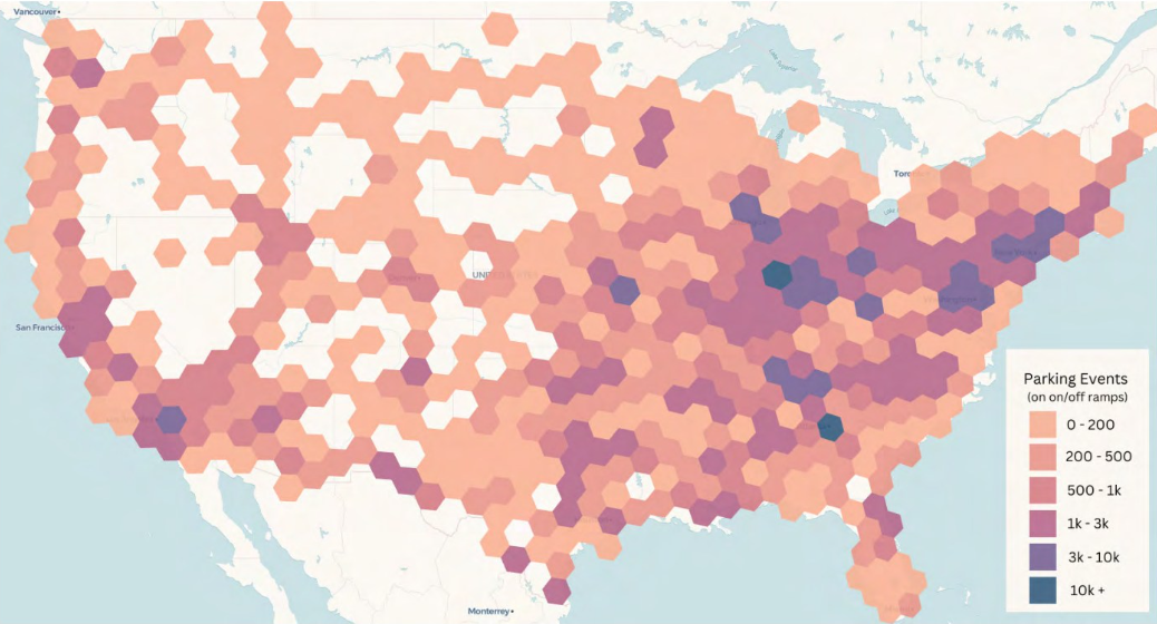
Figure 1: Altitude’s expanded ramp parking event counts by H3 hexes (4,800 square miles per hexagon). Orange indicates low levels of ramp parking and purple shows high levels of ramp parking.
At the “crossroads of America,” Indiana tops the list for metro ramp parking activity and Indianapolis ranks highly on the state list. The subsequent rankings for states and cities correspond to highly populated urban areas in the United States — Atlanta, New York and Indianapolis. High state-level rankings like Tennessee (#3) highlight the impact of major corridor intersections (I-40, I-65 and I-81). These areas may lack large urban centers but they face massive “pass-through” parking demand.
| Top 5 States | Top 5 Metro Areas |
|---|---|
| Indiana | Atlanta–Athens-Clarke County–Sandy Springs (GA-AL) |
| Illinois | Indianapolis-Carmel-Muncie (IN) |
| Tennessee | New York-Newark (NY-NJ-CT-PA) |
| California | Washington-Baltimore-Arlington (DC-MD-VA-WV-PA) |
| Pennsylvania | Los Angeles-Long Beach (CA) |
Figure 2: Indiana, which has more intersecting interstate highways than any other state in the country, leads the country in unauthorized ramp parking.
Urban areas present a particular challenge: They are congested spaces with intense trucking activity but also have high demand for land uses other than truck parking. This combination creates acute parking shortages that lead to high levels of unauthorized ramp parking.
While urban areas see high absolute numbers of ramp parking events, rural areas along major freight corridors also experience significant ramp parking. This suggests that the parking shortage permeates all high-volume freight corridors, regardless of whether they pass through a major city or a rural county.
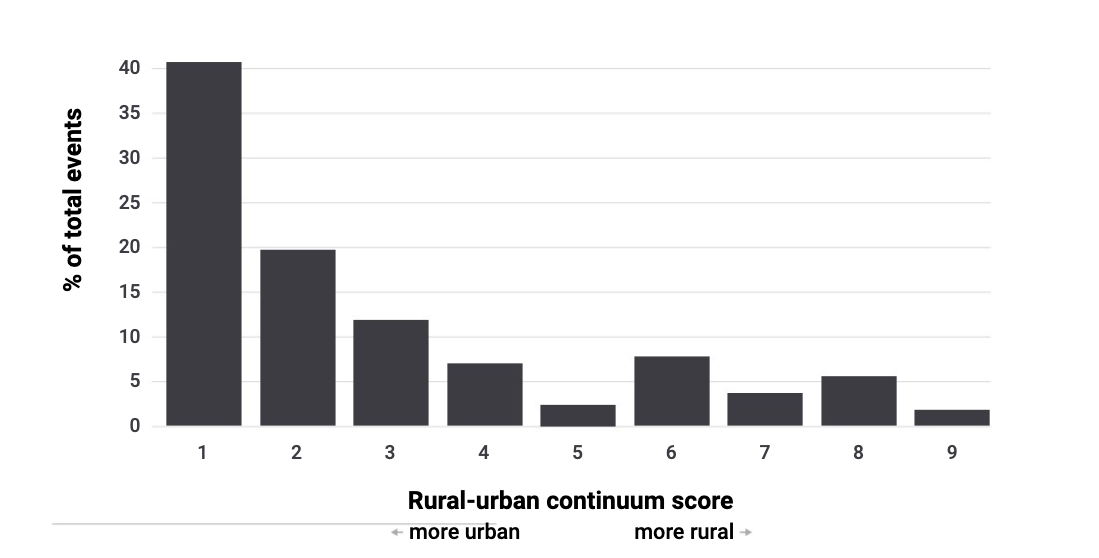
Figure 3: Urban localities lead in unauthorized ramp parking, based on Altitude’s parking analysis applying U.S. Department of Agriculture urban-rural classifications.
Not surprisingly, parking events are most likely to begin between 8:00 pm and midnight. This timing suggests that as drivers approach Hours-of-Service (HOS) limits late at night, they find authorized facilities already at capacity, leaving them with no choice but to stop on a ramp or risk a regulatory violation.
Trucks parked by 8:00 pm typically remain on the ramp until between 5:00 am – 8:00 am the following morning. This means the majority of observed ramp parking events take place overnight. This creates heightened safety concerns for other drivers due to low visibility and unexpected stationary vehicles on infrastructure designed for moving traffic.
Day-of-week analysis reveals that Tuesday has the single highest peak of ramp parking events, closely followed by Wednesday. Friday through Sunday experience lower levels. This pattern reflects the busiest operational days for the trucking industry and aligns with weekly freight volume patterns.
Altitude’s analysis reveals a clear distance-duration threshold: A median journey of 520 miles with nine hours and 40 minutes of drive time—just shy of the 11-hour HOS limit—typically precedes a ramp parking event, while the median journey duration is nine hours and 40 minutes. This means that 50% of all journeys ending in ramp parking events exceed 520 miles and last longer than 9.7 hours.
It appears that drivers approaching their 11-hour driving limit or 14-hour duty limit face a critical decision: continue searching for authorized parking and risk exceeding their HOS limits (incurring fines and violations), or park immediately in whatever location is available — including highway ramps.
These data points indicate that HOS rules, in combination with the truck parking shortage, directly influence truckers’ decisions to park on ramps.
Altitude’s findings enable agencies to prioritize the best corridors for parking capacity expansion. Planners can turn to observed demand patterns rather than anecdotal evidence or uniform geographic distribution. Our report identifies the specific corridors with 5,000+ annual ramp parking events, providing the exact coordinates where new facilities or expanded rest areas would see high use.
Ready to move from recognizing the problem to securing infrastructure funding? Download the full Nationwide Study of Truck Parking on Interstate Ramps to see the corridor-level data you need to justify capacity investments and make meaningful safety gains.
Learn how freight corridor analysis helps planners identify stressed routes, forecast deterioration, plan detours and build defensible strategies to win funding.
Pilot Company is leveraging Altitude’s mobility analytics to prioritize a landmark investment of over $1 billion in enhancing and modernizing their travel center network.
A data-driven analysis of commercial vehicle traffic patterns in San Francisco and Santa Clara during Super Bowl LIX.