
Segment your vehicle counts with behavior-based truck classification data
Stop guessing what trucks are doing in your corridor. Behavior-based truck classification data gives planners the freight evidence needed to write convincing grant narratives.


ATLANTA, GA (April 8, 2026) – Altitude by Geotab, a leading provider of advanced mobility insights and solutions for public and commercial sectors across North America, today announced a strategic partnership with SafeGraph, a provider of global points of interest (POI) data and geospatial intelligence. Through this collaboration, Altitude will integrate SafeGraph’s comprehensive POI dataset directly into its platform, enabling petroleum and gas network operators, logistics real estate analysts, and transportation planners the ability to unlock powerful location-specific competitive intelligence powered by real-world commercial vehicle behavior.
The integration brings together Altitude’s dataset of nearly 6 million commercial vehicles and 100 billion data points with SafeGraph’s database of millions of verified POIs — including fuel stations, truck stops, distribution hubs, and retail locations — complete with brand attribution, building footprints, and operational metadata. The result is a new class of insight: site-level competitive benchmarking grounded in actual truck movement data, not modeled estimates or consumer surveys.
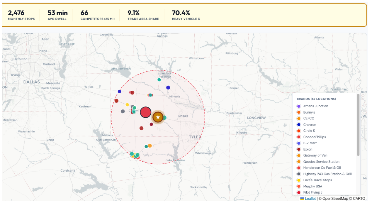
Figure 1: Altitude by Geotab’s location-specific competitive intelligence dashboard, showing commercial vehicle stop data and competitor locations within a defined trade area (illustrative).
“Transportation planners and fuel network managers have long had excellent visibility into their own performance, but almost no ability to see how they stack up against nearby competitors on an ongoing basis,” said Shweta Shah, Associate Vice President of Product & Engineering at Altitude by Geotab. “By integrating SafeGraph’s POI data into the Altitude platform, we are giving our customers the context they need to make confident, defensible business decisions about their locations, their trade areas, and their competitive positioning.”
This partnership will open up future product enhancements like allowing users to select a site within the Altitude platform and instantly surface performance metrics — including stop counts, average dwell time, vehicle class breakdown, and vocation mix — for that location alongside all competitor locations within a defined trade area radius. Because the underlying data reflects actual commercial vehicle stops rather than consumer foot traffic, the insights are purpose-built for heavy vehicle operators and the industries that serve them.
“SafeGraph’s mission has always been to make location data accurate, accessible, and actionable,” said Jason Richman, CEO at SafeGraph. “Altitude by Geotab represents exactly the kind of high-integrity, data-driven platform where our POI data creates real value. Together, we are giving the commercial transportation industry a competitive intelligence capability it has never had before.”
The combined solution is designed for petroleum and gas network operators, truck stop chains, logistics real estate analysts, and any organization that needs to understand how commercial vehicle traffic moves through a competitive landscape.
For more information about Altitude by Geotab and the SafeGraph partnership, visit altitude.geotab.com.
SafeGraph is a leading provider of curated geospatial and points of interest (POI) data, trusted by enterprises, developers, and analysts across retail, real estate, transportation, and beyond. Their global database includes millions of verified POI records with brand attribution, precise building footprints, place geometries, and operational metadata. Altitude by Geotab selected SafeGraph because of the quality, accuracy, and breadth of their POI data — attributes that are essential when pairing location context with high-fidelity commercial vehicle movement data. Together, the two datasets create a level of competitive intelligence that neither could deliver alone.
Consumer location platforms are built on smartphone-derived data, which means they capture general population movement — not commercial vehicle activity. They cannot distinguish truck types, vehicle weight classes, or vocational categories, and they were not designed to answer questions about freight and fuel network performance. Altitude’s data is sourced directly from over 5 million commercial vehicles, reflecting actual truck stops with attributes like dwell time, vehicle class, fleet size, and vocation type. When combined with SafeGraph’s POI context, operators get site-level competitive benchmarking that is grounded in commercial vehicle reality, not consumer estimates.
The integration will enable users to query any location within Altitude and see performance data for that site alongside competitor locations within a defined trade area radius. Available metrics will include monthly stop volume, fuel type distribution, average dwell time, heavy/medium/light vehicle ratios, top vocation categories (e.g., long haul, regional, for-hire, private fleet), and fleet size indicators. Outputs are analyst-ready and queryable by brand, distance, and geography.
The primary audience includes petroleum and gas network operators (such as truck stop chains and fuel retailers), logistics real estate analysts, transportation planners, and any organization that needs to understand how commercial vehicle traffic flows through a competitive landscape. The insights are particularly valuable for operators making site investment decisions, evaluating competitive positioning, or assessing market-wide trends versus site-specific performance issues.
Altitude uses a combination of GPS dwell detection and POI geometry matching to attribute commercial vehicle stops to known business locations. Approximately 50% of commercial vehicle stops are attributable to traditional POI locations — a figure that accurately reflects the reality of commercial trucking, where a significant portion of stops occur at private distribution facilities, construction sites, residential delivery addresses, staging areas, and other non-traditional locations that do not appear in standard POI databases. Altitude only attributes stops when confident in the match, ensuring that the data customers receive is defensible and consistent for benchmarking purposes.
Altitude by Geotab will begin customer pilots in early 2026, with general availability expected later in the year. Interested customers are encouraged to contact Altitude to learn more about early access opportunities.
Altitude by Geotab operates in accordance with applicable data privacy regulations and industry best practices. Commercial vehicle movement data is aggregated and processed in ways that protect customer fleet confidentiality and individual driver privacy. SafeGraph’s POI data is sourced from publicly available and licensed business location information. Neither dataset contains personally identifiable information about individual drivers, fleets or consumers.
This capability is additive. It extends Altitude’s existing commercial vehicle dataset with external POI context, enabling a new category of competitive intelligence insights. Customers will continue to have access to all existing Altitude data products and APIs, with the SafeGraph POI integration unlocking new use cases around site-level benchmarking and trade area analysis.
About Altitude by Geotab
Altitude by Geotab is a leading provider of advanced mobility insights and solutions for public and commercial sectors across North America. Headquartered in Oakville, Ontario, the company leverages its expertise in data analytics to help decision-makers gain a comprehensive understanding of road network movements. By delivering reliable and contextualized insights, it enables improved planning capabilities and better financial outcomes, while maintaining data confidentiality and privacy. Our solutions drive safer, more efficient and more sustainable mobility throughout North America. Learn more at altitude.geotab.com and follow us on LinkedIn.
About SafeGraph
SafeGraph is a trusted provider of curated geospatial data and points of interest intelligence. Its global database of millions of verified POI records — including brand attribution, building footprints, place geometries, and operational metadata — powers location-aware analytics for enterprises, developers, and analysts across retail, real estate, transportation, and beyond. SafeGraph partners with leading platforms including Snowflake, AWS, Esri, CARTO, and Mapbox. For more information, visit https://www.safegraph.com/
Media Contact
Ivana Di Millo
Senior Manager, Strategic Communications
Stop guessing what trucks are doing in your corridor. Behavior-based truck classification data gives planners the freight evidence needed to write convincing grant narratives.
Struggling to justify truck parking infrastructure investment? See how Atlanta’s truck parking demand analysis reveals the methodology, cost data and Tuesday-night diagnostic every MPO and DOT needs.
5 ways freight corridor AADT data in 90 days supports federal counts—get timely, class-specific truck volumes for better planning.