ATLANTA, GA (July 25, 2025) – Using data from over 16,000 vehicle trips, a new study from Altitude by Geotab provides the first comprehensive look at the New York City congestion pricing (CP) program’s impact on freight movement in Lower Manhattan. The analysis reveals significant changes in commercial traffic flow and the types of vehicles driving through the congestion zone.The analysis shows no substantial change to idling metrics in the congestion zone area.
New York City’s highly anticipated CP program rolled out at the start of 2025 with the aim to alleviate gridlock in Lower Manhattan. While initial reports of the program’s effectiveness primarily focused on passenger vehicles, Altitude by Geotab’s early data analysis now paints a clear picture of the program’s initial effects on commercial vehicle movement, critical for the city’s supply chain and last-mile delivery. The study looked at data from January through May 2024 compared to the same five-month period in 2025 to understand how commercial fleet activity changed after the introduction of congestion pricing.
Key Findings for Commercial Traffic in Congestion Area:
- Truck Traffic is Moving Faster: Between 8 a.m. and 6 p.m., 44% of Lower Manhattan roadways saw faster commercial vehicle travel times (40% unchanged).
- Fewer Large Trucks, More Multi-Purpose Vehicles: A noticeable decrease in the number of larger (medium- and heavy-duty) trucks entering the congestion pricing zone was observed, with a corresponding increase in multi-purpose vehicles.
- Idling Behavior Largely Unchanged: Despite improved traffic flow and a shift in vehicle types, analysis has not shown a substantial change in how long vehicles spend idling within the zone.
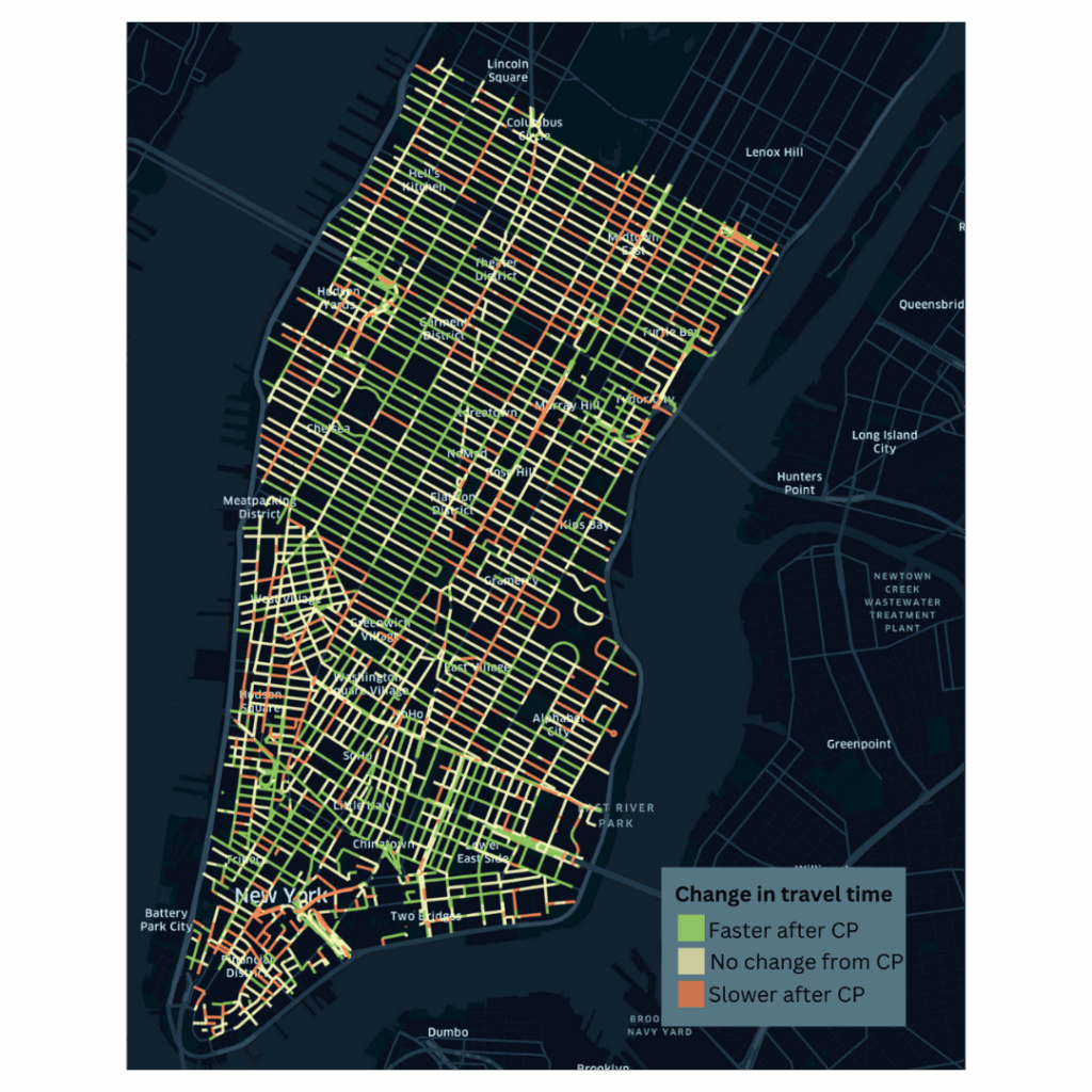
The map shows how average travel time on each road has been impacted by CP.
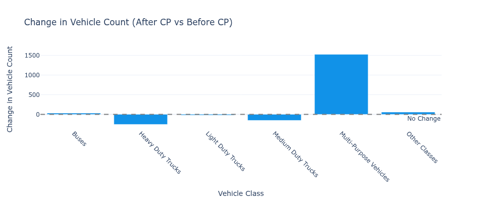
The analysis shows a noticeable decrease in the number of large trucks (medium- and heavy-duty) and an increase of multi-purpose vehicles in the congestion zone.
“Data insights are crucial for understanding and optimizing the dynamic world of transportation,” notes Nate Veeh, AVP, Business Development, Altitude by Geotab. “This study is a great example of how insights into a real-world problem like traffic congestion and introducing tolls can help us understand the impacts on traffic flow, fleet composition and idling. By leveraging this information, transportation planners and city officials can make informed decisions about transportation options that show results, whether it is to enhance safety, improve efficiency, or facilitate better planning for the movement of people and goods.”
These initial insights from Altitude by Geotab underscore the power of detailed freight mobility data to deliver a deep understanding of evolving urban dynamics and supply chains. As cities like New York implement transformative policies, continuously analyzing complex interactions between vehicle types, traffic patterns, and operational habits through robust data becomes foundational for informing decisions that shape efficient and sustainable urban environments for all.
For more information, visit https://altitude.geotab.com/news-and-releases/nyc-congestion-pricing-analysis/