Skip to Main Content

TETC Vendor Info

Understand how and where connected trucks and vehicles travel with Altitude by Geotab.

Get critical insights into commercial traffic volumes and activity

To make the best possible freight and infrastructure planning and modelling decisions, you need to know the types of vehicles on your roads – and how they use them. With access to millions of connected commercial vehicles available through the Altitude platform, Origin & Destination and Freight Analytics connects you to rich transportation data that helps you understand the true purpose of road trips, so you can plan more effectively.

Plan smarter from point A to Z

Whether you want to analyze the true origins and destinations of vehicle movement throughout your state or jurisdiction, index popular routes from a port or understand travel time metrics from one commercial hub to a specific geopolitical zone, you have the flexibility to investigate months of data within minutes – easily and on-demand.

Assess situations, observe trends and make better freight planning decisions based on aggregate connected-vehicle activity. With Origin & Destination and Freight Analytics, you tap into these benefits and more:

Gain access to Geotab’s vast commercial vehicle data network to support strategic, informed, and cost-effective freight planning at a statewide macro-level or at a granular micro-level such as census tract or TAZ areas.

Identify the types of vehicles that use your roads and how, for effective planning that accommodates all types of commercial traffic, including light- medium- heavy-duty trucks and multi-purpose vehicles, all of which can be filtered by class 1-8.


Generate and visualize tailored origin-destination insights that reflect the data you care about, including custom-defined regions of interest and filters such as trip chaining for relevant metrics, journey definition, vocation, industry, and vehicle class.

CORE ALTITUDE TETC MARKETPLACE OFFERING

Origin & Destination and Freight Analytics are Altitude by Geotab’s Core TETC offerings which help you unlock the insights you need through a rich set of features and filters, including the following:

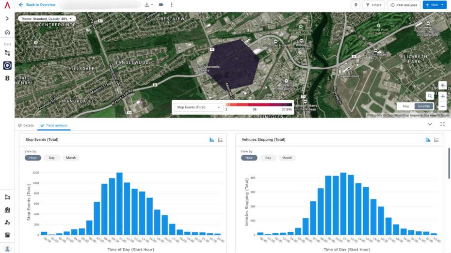
Origin & Destination Module

The Origin and Destination (O/D) module offers detailed insights into vehicle movement patterns through a flexible analysis tool. This module supports strategic infrastructure planning, efficient logistics and regulatory compliance by helping transportation planners, commercial developers, city officials and traffic engineers optimize vehicle movement patterns for enhanced transportation planning and infrastructure development.

Vocation classification

Our patented machine learning model examines driving behavior to automatically classify trips and vehicles into categories according to a vocation or purpose, including long haul, hub-and-spoke delivery or last mile door-to-door delivery.

Vehicle classification

Understanding how certain classes of vehicles use your roadways is critical for effective planning decisions. Altitude by Geotab provides insights into all classes of vehicles ranging from multipurpose vehicles, light-duty, medium-duty, and heavy-duty trucks, passenger vehicles, buses and others.

Journey definition

To understand commercial vehicle movement patterns at aggregate, you need to capture a journey’s true origin and destination. Origin & Destination lets you chain individual trips together to ensure intermediary stops don’t skew the data.

Speed of analysis

While OD analysis can sometimes take hours, the Altitude platform shortens time to insight, processing months of data for large jurisdictions in just minutes.

Expansion factors

To better understand road networks, Altitude by Geotab offers state-level expansion factors for all 50 states in the USA using a tailored weighting methodology over discrete locations which ensures more accurate and versatile data for freight planning and operations.

ANCILLARY TETC MARKETPLACE OFFERINGS

Beyond our Core offerings of Origin & Destination and Freight Analytics, see what other macro and micro level analysis can be performed with additional Altitude products. Whether you’re examining a corridor that spans several states, or zooming into transportation or parking behaviors at a specific location like a port or warehouse, the Altitude platform gives you the rich insights you need to make informed decisions.

Stop Analytics Module

Our data is aggregated transparently and consistently to offer the most accurate custom reporting possible for your parking planning needs. The simplified, flexible Altitude platform helps public entities distinguish between vehicle stops and parking patterns on individual roads, within zones of interest or across national highways. Plan for safer roadways, placement of electric vehicle infrastructure and more efficient curbside management.

Traffic Analytics Module

Altitude’s Traffic Analytics Module combines leading commercial vehicle and freight data with open-sourced street data. Get an expansive and granular picture of your road traffic flow including measurements such as travel times and spot speeds—from individual segments to combined streets. And dive into municipality and citywide road traffic data to create more efficient vehicle flow and minimize accidents.

Regional Travel Metrics Module

Understand and provide high level mobility insights related to geographies of interest with Regional Travel Metrics. Analyze how much commercial vehicle movement has occurred like distance traveled (VMT/VKT), number of observed trips, and number of unique vehicles to serve as the underpinning to deeper insights related to state freight plans, infrastructure decisions and assessing vehicle emissions.

Expansion Factors

Break down traffic volumes into market-representative vehicle categories, including heavy, medium and all commercial and non-commercial vehicles. This Altitude feature enables precise planning for truck and freight parking on various road segments, helping you optimize new infrastructure placement and utilization.

About the Altitude Platform

Altitude by Geotab provides reliable and contextualized mobility insights for decision-makers to gain a complete understanding of movements across road networks. The following table outlines our core product suite for TETC members versus our specialized ancillary products:

Product Core Ancillary
Origin & Destination (OD) / Freight Data
Regional Travel Metrics
Stop Analytics
Traffic


These products are specifically curated for TETC members. To see how these tools integrate into our full suite of platform capabilities, click the button below to watch our comprehensive platform overview.

Altitude elevates freight plans

Talk to our team to learn how to access Altitude by Geotab through our Eastern Transportation Coalition vendor partnership.