How planners can forecast freight bottlenecks
Proactive state freight planning starts with early bottleneck detection. Learn how Altitude’s data helps planners identify emerging issues, rank corridors and build smarter solutions.

The green transportation revolution keeps trucking on and its next stop is freight electrification. Trucking continues to be a major contributor to the transportation sector’s carbon footprint, accounting for nearly a quarter of all greenhouse gas emissions despite only representing 10% of the vehicles on the road.
Proactive steps are being taken to electrify trucking with improvements to range and haul capabilities but there still needs to be more certainty around the transition to electric. Wanting to take a deeper look into the viability of truck electrification, Rocky Mountain Institute (RMI) chose Altitude by Geotab as their trusted source for freight movement data across the U.S.
With unrivaled visibility into where, when and how trucks are driving and stopping along major U.S. highway networks, coupled with insights into vehicle class and engine type, Altitude by Geotab data is the perfect source for beginning to understand which trucks would make the most sense to electrify. It’s why RMI chose Altitude by Geotab as their data source partner to develop the first trucking electrification dashboard to show how some early adopting states are faring.
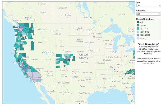
Check out Altitude by Geotab data in action on RMI’s new electric trucking dashboard. Dive into not only which types of trucks are the best candidates to electrify but also how much energy those trucks will need to stay on top of charging requirements and what those charging schedules might look like.

Breaking down by county how many trucks are electrifiable. Analysis shows over 200,000 trucks in California including 60,000 in LA County could be electrifiable.
The analysis is in the early stages, looking initially at the first 15 states that have signed a memorandum of understanding stating their intent to follow California’s ambitious Advanced Clean Truck Act regulation. Still, there’s quite a bit of information to be gleaned from the dashboard — answers to questions that charging infrastructure planners will need.
With an understanding of the driving patterns and behavior of trucking using Altitude’s data, baselines can be established for the number of trucks on the road in a given day, the number of miles driven and what kinds of trucks are driving those miles. Armed with this info, planners can start to slice and dice the data to inform decisions around where to place electric vehicle infrastructure knowing how much energy is needed to accommodate those truck journeys.
Impacts on the grid and calculations of air quality improvement can also be more easily understood. This information helps foster better collaboration across utility planners, city officials and transportation authorities to make data-driven decisions that evolve alongside truck electrification.
For more information about this truck electrification project, check out the RMI dashboard. If you have a data project that you’d like to work with Altitude by Geotab on, contact us here to learn more about our partnerships.