Skip to Main Content

Freight Planning Platform

Built for State Freight Plans. Powered by Real-World Truck Movement.

Stay ahead of the curve

Freight planners face growing pressure to submit federally compliant freight plans, justify investments and solve complex infrastructure needs. Altitude provides granular, first-party commercial vehicle data—fully privacy-safe and aligned with BIL/NHFP mandates—to help planners confidently prioritize projects and secure funding.

Justify investments with confidence

Use Expansion Factors and vehicle-classified VMT to create defensible project justifications aligned with NHFP, RAISE and INFRA grant expectations.

Regional Travel Metrics (RTM) reveals scalable VMT, congestion trends and route usage by truck class—empowering corridor prioritization and compliance with FAST Act metrics.

Stop Analytics with Hourly Parked Events provides the full picture of truck parking behavior—where trucks remain parked, not just where they stop—informing rest area planning and EV site selection.

Analyze O & D flows and freight hub activity with regional and cross-jurisdiction insights—futureproofing plans for rail, port and highway coordination.

Create zone-specific insights for grant regions with Custom Zones, Expansion Factors and defensible metrics that hold up to FHWA and USDOT scrutiny.

Keep your plan up to date with Altitude

Build fundable, compliant freight plans with Altitude’s scalable traffic metrics, defensible parking analytics and intuitive planner tools—all designed to reduce time-to-insight and increase confidence in your investment strategy.

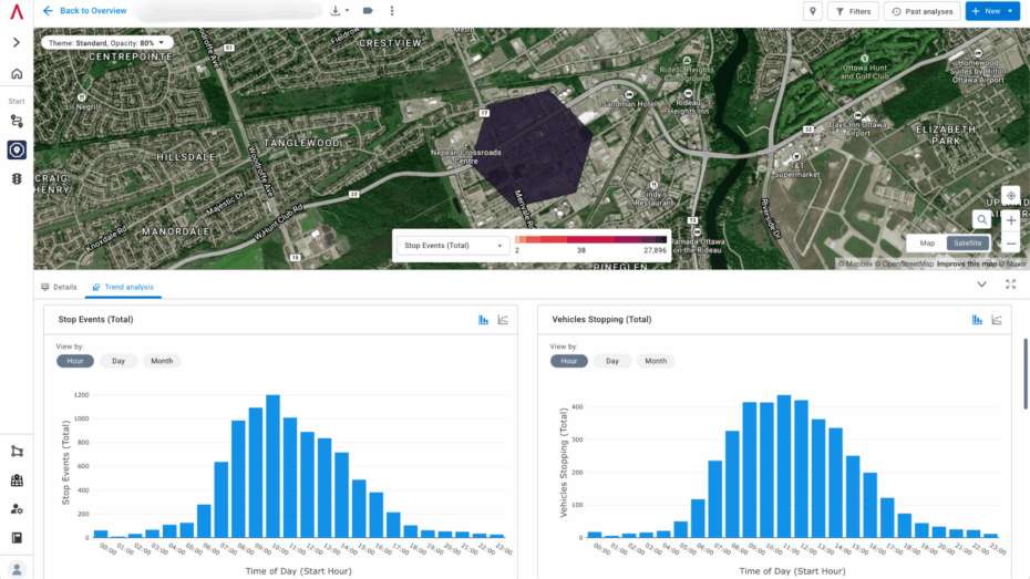
Origin & Destination Module

With the ability to create full journeys by chaining trips together over multiple duty cycles, understand true origins and destinations to better manage the movement of goods. Uncover the context behind journeys with detailed insights into commercial vehicle movements, reporting on vocation, class and industry.

Route Analytics

Analyze routes between origin and destination pairs to gain metrics such as journey counts, vehicle breakdowns and travel times. Quantify the relative importance of different infrastructure elements used to support freight movement. Route Analytics provides detailed insights for all commonly used routes.

Traffic Analytics Module

Understand traffic patterns per road segment, including interstate highways, major arterials, connectors and more. The Traffic Analytics module offers critical traffic-related information for safer road design and efficient freight movement, helping transportation planners optimize routes and achieve compliance.

Stop Analytics Module

Gain insights into heavy-truck parking patterns to inform freight parking plans. This module provides a comprehensive understanding of where and why vehicles are stopping, enabling stronger planning.

Regional Travel Metrics Module

Gain insights into basic vehicle characteristics and the observed vehicle distances traveled within a specific geography. This module provides essential metrics for regional travel analysis, such as AADT (Annual Average Daily Traffic), aiding in comprehensive regional planning and infrastructure management.

Expansion Factors

See beyond trip data to breakdown traffic volume with context into market-representative heavy, medium and all commercial and non-commercial vehicles for Motorway, Primary, Secondary, Tertiary and Trunk road segments. Improve transportation planning precision and project management using accurate expansion factor data.

About the Altitude platform

Altitude by Geotab delivers privacy-safe, first-party mobility insights for transportation decision-makers—enabling better freight planning, faster funding justification and more resilient infrastructure strategies.

As the source of both data and analysis, Altitude maintains unmatched transparency, confidentiality and context across all road network movements.

Elevate freight planning

Discover how Altitude empowers confident freight planning—from uncovering true parking demand to prioritizing congested corridors. Book a demo today to see the Freight Planning Platform in action.

Frequently Asked Questions

A: Altitude is built on first-party data from over four million commercial fleet vehicles connected through Geotab. To maintain defensibility, we validate our data using FHWA HPMS ground-truth traffic counts and published AADT benchmarks. Each data point includes rich context such as vehicle class, fuel type and vocation—allowing freight planners to move beyond volume counts to true corridor and parking behavior analysis. For more information about our commitment to data privacy, visit https://altitude.geotab.com/data-privacy/.

A: Privacy and compliance are built into every layer of Altitude. We use anonymization, secure encryption and PI Safe data layer processing to protect every trip, stop and behavior insight. Our platform meets or exceeds all applicable state and federal privacy regulations—so transportation agencies can confidently use detailed truck movement insights without risk. For more information about our commitment to data privacy, visit https://altitude.geotab.com/data-privacy/.

A: Altitude classifies every commercial vehicle trip by fuel type, vocation, class and industry segment. This context enables planners to perform vehicle-type-specific planning (e.g., heavy-duty diesel vs. electric), evaluate zero-emission readiness and understand freight behavior far beyond basic traffic volumes.


A: Our platform uses high-frequency GPS sampling, consistent expansion methodology and segment-level validation to deliver reliable metrics like VMT, AADT and idling. All methodologies are transparent and documented—maintaining audit-readiness for federal funding, FHWA submissions and inter-agency collaboration.

A: Altitude offers both a visual UI and direct API access. You can filter and download reports for offline use or connect your planning environment to our API for seamless integration with STIP/TIP systems, GIS platforms and grant documentation tools.