
Shape the future of road safety & traffic insights with the Altitude Beta Participation program
Our goal is simple: to provide you with the tools and insights you need to drive positive change in your organizations and communities.


For the Altitude team, our journey is driven by a commitment to providing the best possible insights to our customers. We understand that data, while valuable, is only as useful as the insights it generates. This principle guided us through developing the updated Expansion Factors 3.0 model and supporting modeled AADT counts, which are significant upgrades to our Altitude platform. This story isn’t just about technical advancements—it’s about how we listened to our customers, responded to their needs and improved our tools to better serve them.
Our journey began with listening. Version 2 of Expansion Factors had already set a foundation for providing valuable traffic data, but we knew there was room for improvement. Customers frequently shared their challenges and needs with us, highlighting the necessity for more granular and accurate data. They needed insights they could trust, derived from transparent methodologies, and applicable to critical planning and decision-making processes.
In Version 2, we used TMAS (Travel Monitoring and Analysis System) data and FHWA’s (Federal Highway Administration counting stations as our primary data sources. While this provided a solid foundation, the limitations became clear. We had approximately 14,000 directional stations, which, while significant, were not enough to offer the comprehensive insights our customers needed for detailed traffic analysis. The expansion factors were limited, and customers wanted a broader scope, encompassing various vehicle types and more precise traffic patterns.
Transparency has always been a cornerstone of our approach. Understanding the importance of this to our customers reinforced the need for meticulous documentation of our data collection, processing, and expansion methodologies. Our commitment to clarity ensures that every step is transparent, allowing customers to see exactly how we achieve our market-representative numbers. This dedication to openness builds the trust and reliability that our customers expect.
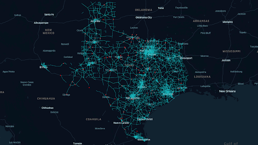
Figure 1: Example of improved coverage in Texas. V 2.0 discrete locations (Red) vs V 3.0 continuous segments (blue).
Recognizing these gaps, we embarked on a transformative journey. Expansion Factors 3.0 with AADT (Annual Average Daily Traffic) is the latest upgrade to the Altitude platform, offering unmatched model transparency for trustworthy volume estimates . Version 3 introduces a completely new approach to calculating traffic data, transitioning from FHWA counting stations to HPMS (Highway Performance Monitoring System) AADT data, and expanding to eight million road segment edges. This significant increase enhances granularity, accuracy and confidence, making the data highly useful for statistical analysis, traffic trends and market insights.
The new model enhances HPMS AADT data to support use cases that require a comprehensive understanding of total vehicle population and traffic volume, where sampled data alone is not adequate. By changing our approach to focus on road segments, we provide more accurate and comprehensive insights into traffic patterns. By pulling data from the full network for AADT (motorway, trunk, primary, secondary and tertiary) instead of discrete locations, we reduced sampling bias, noise and outlier bias. The new model reports by road type and creates five AADT models, one per road type, each with its own R², improving the reliability and precision of the data.
“Incorporating HPMS AADT data into our models has significantly enhanced their accuracy. The increased number of sampling points allows for a more detailed and precise analysis, leading to better-informed decisions and more reliable expansion factor estimates.”
– Kasra Azizbaigi, Senior Data Scientist
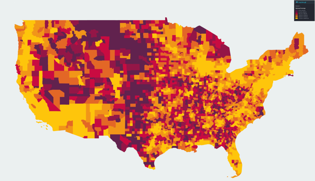
Figure 2: Expansion Factors 3.0 is built on modeled AADT which has an average R² of 0.902 across all supported road types, allowing us to provide accurate traffic volume expansion across county-level road segments in the United States.
With our expanded data set and transparent methodology, we focused on enhancing data integrity. Reliability starts from the source, and Altitude is that source, with data from over four million commercial vehicles. This allows us to offer detailed insights into vehicle type, vocation and class. By using source vehicle data, we provide greater context, including vehicle types, vocations and industry tracking over time. This comprehensive approach offers insights not possible with third-party data sources, enabling our customers to rely on data that truly represents real-world road conditions.
“When planning for infrastructure, we understand the importance of having accurate and comprehensive data. With access to over 4 million commercial vehicles, Altitude’s insights not only meet these needs but also provide rich contextual information that is unmatched in the market.”
– Shweta Shah, AVP, Product & Engineering
We designed Expansion Factors 3.0 to meet the diverse needs of our customers and partners. This version offers enhanced granularity and precise data, essential for a wide range of applications. City planners can model traffic flow changes, highway authorities can adjust traffic policies, and developers can plan commercial real estate projects with confidence. The improved granularity supports high-confidence vehicle estimates for projects like parking analysis, infrastructure development, congestion management and safety projects.
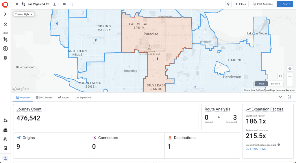
Figure 3: A view of the Expansion Factors information provide in the overview view within Origin & Destination.
Shaped by customer feedback, these updates provide transportation planners with accurate, granular traffic data. Our transparent methodology ensures you can trust the insights derived from our enhanced sampling techniques. Expansion Factors 3.0 is built with key features that offer unmatched detail and accuracy to meet our customers’ needs.
Our goal is simple: to provide you with the tools and insights you need to drive positive change in your organizations and communities.
Learn more about our expanded trip chaining options within the Geotab ITS Altitude platform which allows more custom analysis for users.
Altitude by Geotab’s platform unveils new vocation classifications to gain understanding of vehicles’ purpose on the road.